


When and where did the idea of the urban beach emerge? A study investigates how Los Angeles debated the way the beaches and the city should be combined in the 1940s. The ideal urban beach was then progressively defined in terms of functionality, orderliness and respect for nature’s whims.
|
Installing large expanses of sand in an urban setting is one of the latest trends in urban planning in order to implement leisure at the heart of major cities [1]. The first artificial beach of such kind was arguably created in London in 1934 when 1500 tons of sand were dumped along the Thames below the Tower of London. Tower Beach, as it was called, enjoyed a large success throughout its existence, especially with the lower classes who could not afford a trip to the seaside towns. Only around five hundred people could frolic on the sand at one time, and the quality of water was far from ideal, but it attracted large crowds of Londoners. Closed during the war, Tower Beach reopened in 1945 before definitely shutting down in 1971 because of pollution. [2] The concept was recently revived and an urban beach craze seems to have taken over Europe and the United States. A term was even coined to describe the increasingly popular phenomenon: “urbeach.” Since “Paris Plage” (literally “Paris Beach”) started in France in 2002, Birmingham, Berlin, Las Vegas, Amsterdam, Rome and New York City have inaugurated their own versions of the “urbeach.” [3]
However, the idea of an urban beach that would both, as a natural environment, inspire the city dweller to relax and, as a well-planned public urban space, allow for an important crowd to have access to, park its cars, eat and enjoy a day at the beach is not something new. Nor was Tower Beach. Major cities naturally endowed with long stretches of sandy beaches have struggled with this question since at least the early twentieth century. Los Angeles is an especially interesting locale to look at these issues as it witnessed a tremendous demographic growth in the 20th century, was renowned for its scenic strands and beach lifestyle, and cruelly lacked public spaces dedicated to recreation.
Plaidoyer for a History of the Urban Beach
While historians have given much attention to the significance of the emergence of urban parks, [4] the phenomenon of the urban beach has been neglected. Social historians of tourism interested in resorts and the beach life have generally pushed the urban issues out of their narratives, preferring to detail the processes through which fishers were progressively forced out the seaside or describing the resort life from a social or cultural history point of view. [5] Moreover, the Los Angeles case presents something new: Los Angeles became a resort at the same time as it became a city, and it kept resort-like features even as it was turning into the urban sprawl we know today. Secondly, historians of tourism have neglected the environmental consequences of the resorts’ fast-paced development. They also rarely focus their attention specifically on the beaches although these are the most contested and valued aspect of the coast. [6] These spaces deserve their own history; one that would take into account the environmental challenges which afflicted the beaches during the 20th century and analyze the relationships between the postwar urban growth, the advent of the automobile and the shoreline’s development.
Such a history requires specific sources. In Los Angeles, a surge of surveys, reports and plans were put together in the 1940s to reflect on how best to combine the beaches and the city. Indeed, urban beaches raise specific problems in terms of urban planning; pollution, erosion, lack of accessibility due to traffic and parking problems are some of them. When reading these documents the difficulties of blending these two antagonistic environments is striking and several questions come to mind: how can one pursue the beachgoer dream in an urban context? How did the urban context modify the contemporary beach experience? How was the ideal urban beach imagined and realized in the context of the metropolis’ growth and the emergence of environmental awareness? Was it considered a priority or, on the contrary, a frivolous pursuit in comparison to the roads and buildings the growing postwar population desperately needed? A good place to start looking for answers is the Santa Monica Bay, the coastal indentation along which lies the Los Angeles metropolitan area. Indeed, it encloses the most famous sandy beaches of the region, whereas industrial activities were confined to the South in the San Pedro Bay. What follows is an analysis of the vision of the ideal beach according to local public authorities, engineers and planners. The ideal beach according to everyday beachgoers would require its own study and would probably present very different features.
Beaches for the Urban Masses?
Los Angeles has a unique demographic history: no other city in America has ever grown so large so rapidly in the 20th century. This uncontrolled growth was what supposedly spawned one of the first studies of the beaches’ situation. In 1930, the first long-range report dedicated to the “parks, beaches and playgrounds of Los Angeles” released by the Los Angeles Chamber of Commerce, [7] raised the alarm: Los Angeles and its region was going through a “crisis” as nothing was done to increase outdoor leisure opportunities while the city was experiencing the most prodigious boom in its history with the county population more than doubling from approximately 900 000 to more than 2 200 000 between 1920 and 1930. [8] The report urged the public authorities to take matters into their hands, especially regarding beaches and their public accessibility. If actions were not taken, the unlimited access to nature that characterized life in urban Southern California and distinguished it from the Eastern cities would be gone for good.
The plan proposed in the report was never adopted and the situation festered. Apart from the haphazard acquisition of stretches of beaches by the state park commission [9] in the early 1930s nothing was done to provide more parks and beaches to the increasing population or to make the existent ones more accessible and functional. During the 1940s, however, several surveys and reports started circulating in the Los Angeles region regarding the development of the city’s coastline. A Master Plan was devised at several scales (local, but also county-wide and later on state-wide) to improve—or sometimes even create from scratch—the Los Angeles coastal landscape. [10] Unlike the 1930 report, this plan did not go forgotten and was indeed applied, or at least most of it. The Los Angeles’ coastal landscape of today is the heir of this program.
Slums on the Shore?
If in 1930 the authors of the report invoked the “crisis” plaguing the region, the 1940s studies were even more alarming. The urban public beaches of the region were in “deplorable condition” [11] and even compared to “seaside eyesores.” [12] It was actually not a question of development of the beaches anymore, but rather one of “restoration.” [13] According to the California Beach Association Bulletin, the phrase “public beach” was associated in the minds of many people to an “unpleasant picture”: “over-crowded, littered up, inadequate parking, very noisy, small and unsanitary facilities, the whole nourished by smelly ramshackle hot dog stands skilled in the preparation of dubious hamburgers.” [14] This description summed up most of the so-called “problems” identified in these 1940s studies.
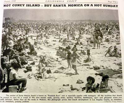
According to these reports and plans, this situation was the result of the city’s transformation into a huge metropolitan area. First, thanks to the second demographic boom of the region, which brought the Los Angeles post-war population to 3.4 millions, the beaches were “overcrowded.” This was not a new problem as the 1930 plan already compared unfavorably the beaches of Los Angeles to the famous Eastern beaches. Even Coney Island, which was considered at the time the “world’s most heavily used beach” [15] as Robert Weegee’s beach crowd photographs famously illustrated, was in a better shape with an average of 56 square feet of beach above water-line per person compared to only 15 on Santa Monica on the afternoon of July 4th, 1928. [16] In the 1940s, the comparison was even more stinging since a new project had clearly shown the superiority of the East coast concerning beach development in an urban setting. Jones Beach on Long Island was indeed opened in 1929 with the press of the entire country in awe of “the most beautifully landscaped of beaches.” [17] The creation of Robert Moses, the famous New York City park commissioner, Jones Beach had become the reference in terms of minimum space of sand per person for a city beach (64 square feet).
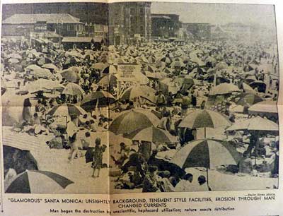
The Los Angeles Master Plan intended to do better however. With 75 square feet of sand area per person, the 1949 engineering report written by the firm Madigan and Hyland planned on setting up a new standard for the ideal urban beach, both comfortable and attainable. [18] The Greater Los Angeles Citizens Committee whose report was funded by private sources went even further, asking for a minimum of 150 square feet. [19] The numerical escalation was evidence that the modern urban beach was a contested ideal fraught with economic calculations, and regional competition. At stake was not so much the Angelenos’ comfort but rather the reputation of Los Angeles as the “good life” city, a reputation that could be counted in tourist and retiree dollars. [20] Catching up with Jones Beach was as much a question of regional pride as it was a sound economic decision. The specialized press often used the images of overcrowded Santa Monica to suggest the unhygienic conditions existing at the beaches but more generally the unsightly vision tourists and potential new residents looking for “Glamorous Santa Monica” would have once arriving on the strands. These pictures represented the urban beach at its worst; nowhere was any “natural” element in sight, the beaches were now swollen by the city, as if they were not only one of its neighborhoods but a rather shabby one. Beaches were indeed associated with slums: crowded, dirty, noisy and with “tenement-style facilities.” [21]
The entire bay was not overcrowded however. In Malibu for instance, where closely built buildings often prevented the public to access the beaches, private owners had a large share of the beaches. The plans did not mention this fact nor did they challenge the existence of most private beach clubs which were considered “semi-public” facilities which “served usefully a large public in their own membership.” [22] The mention of the beach clubs was actually the only hint in the plans and studies to the different socio-ethnic uses of the beaches. Nowhere was mentioned the fact that certain stretches of the beaches were only used by African-Americans or that groups of Mexican-American teenagers were often told to leave the beach front by the police or residents. [23] Nowhere was it indicated that lesbians and gay men congregated to certain parts of the Santa Monica and Venice beaches or that the working-classes were often found near the amusement parks in the famously congested areas of the Venice, Ocean Park and Santa Monica piers. [24] The reports and studies described the beaches as if they were used by Angelinos who did not behave differently depending on their gender, race or class. They muted all kinds of social or racial conflicts and divisions, choosing instead to speak in broad terms of congestion problems.
Trash, Pollution, Infection…
The second adjective used to describe the California beaches, “littered up”, was especially worrisome for the authorities. A crowded beach also meant a dirty beach at the end of the summer season, which is why the Master Plan planned the use of regular maintenance crews. However, the cigarettes and papers left by beachgoers on the sands were not what could most badly hurt the beaches. Indeed, the demographic growth was a problem in terms of feet of sand per person but more importantly, in terms of sewage. “During the past ten years, the amount of raw sewage reaching the shores of all the cities along Santa Monica Bay has been increasing to an alarming extent” explained the authors of the Sanitary Survey of Sewage Pollution of the Surf and Beaches of Santa Monica Bay, one of the many coastal studies realized in the 1940s. [25] While the California State Board of Public health had alerted authorities that the sewers were overtaxed, nothing had been done to increase their capacity. The beaches were directly concerned by the issue as the untreated sewage produced by this growing population was in large part poured into the sea at Hyperion Beach in Santa Monica Bay. In 1942, not only did the report state that intestinal diseases were known to be three times as frequent in proportion to population in the adjoining shore area as they were elsewhere in the state, but a quarantine was established on 10 miles of Venice beaches. Interestingly enough, the Venice area was also the part of the bay which was heavily patronized by racial and ethnic minorities, as well as by the city’s working-classes. The quarantine was not lifted before 1950 when the brand new sewage disposal plant and new outfall sewer lines were inaugurated at Hyperion. Governmental agencies were not alone responsible for this situation since the public had five times defeated bond issues to remedy these conditions. The quarantine situation, although vehemently denounced by the master plan and studies of the period, was only resolved when the state sued the responsible cities. Beaches in the city apparently appeared then more as a luxury rather than a need for the population, especially for people living far from the shores and at a time when so many facilities needed to be upgraded in order to serve a growing population.
Creating Another “Automobile Beach”?
The third reproach pronounced against the beaches, “inadequate parking”, was again a typically urban problem. In a city like Los Angeles, which cruelly lacked public transportation, it was a serious challenge. However, it was hardly a unique phenomenon to Southern California. Widespread car ownership was a specificity of Los Angeles since the early 20th century, but most American cities underwent profound changes in the 1940s and 1950s to accommodate the growing numbers of motorists, most notably through the construction of urban freeways. Pointed out in 1930 already, the parking issue intensified the crowding problem as beach-goers swarmed the beaches where there was available parking while long stretches of sand went untouched because they were inaccessible. As in the crowding problem, Robert Moses had admirably solved it by constructing the parkways connecting New York City to the beaches on Long Island and vast parking areas. Jones Beach was the typical “automobile beach,” which the aerial photographs featured in the Los Angeles newspapers made perfectly clear. [26] The ideal urban beach, these articles lamenting the parking situation seemed to imply, had become one that could boast more parking acres than sand acres. The Master plans therefore made sure new parking spaces were included in the beaches development. However, the highly developed character of the region’s established beach communities prevented the adoption of the exact parking schemes of Jones Beach. If not on the concrete, space for cars had to be provided on the sand itself: this is what happened in Venice Beach where the beach was widened several hundred feet for a distance of about 7 miles by the supposedly “simple expedient” of placing on it excess sand from the site of the new sewage treatment plant at Hyperion. [27] One problem was therefore solved at the same time as another pressing one: by constructing the plant, the authorities had found a great way to artificially extend the beaches and turn them into giant parking spaces.
The fourth problem pointed out in the quotation used earlier (“small and unsanitary facilities”), concerned the lack of recreation facilities (bathhouses, toilets, etc.) and proper food stands. The Master Plan acknowledged the lack of bathhouses on the Los Angeles coast, especially compared to the beautiful ones constructed at Jones Beach. According to a 1949 study made by the city of Los Angeles, the lifeguards were unanimous in their assertions that the people of Los Angeles did not want nor need bathhouses, because they preferred to drive to the beaches in their bathing suits or to change clothes in their parked cars. Were the bathhouses “a thing of the past” [28] since everybody now owned a bathing suit and came to the beach by car? The study’s goal was to plan the modern urban beach, not one that belonged to the past. We find here again evidence that the ideal urban beach was an evolving and indefinite model. The study’s authors concluded that bathhouses were still desirable for older people and that building more bathhouses of the “modern” type would create more demand. Maybe the other reason was that the vision of a proper beach according to public authorities was one in which the undressing part of the beach experience was kept behind closed doors.
While not mentioned in the quotation used above, the erosion problem was the most pressing according to the plans and reports. Maybe the reason why it had not been noted was that it was not the most visible, at least not to most people’s eyes. The city’s demographic growth had not only brought more people to the city and its beaches. It had also led to their development through elaborated coastal engineering projects (breakwaters, jetties, groins, etc.) starting in the early 1930s. According to the 1940s studies realized in preparation for the Master Plans, there was “little room for doubt” [29] that erosion had been caused by the interference of man-made structures with the natural stabilizing action of the ocean waves and the littoral drift. A good example of these processes is the Santa Monica breakwater built in 1934 in order to create a yacht harbor in front of the city. The breakwater was already considered a coastal engineering fiasco in the 1940s as it prevented the South-East littoral currents to act as usual, bringing sand down to the South. A huge sand salient quickly formed up north, in the city of Santa Monica, while down south Venice beaches were badly eroded. The major and costliest project brought on by the Master plans was to fill out through beach nourishment projects to the width of the salient. This would not only restore the eroded beaches but widen them, which eventually created more space for new facilities or cars as had been the case in Venice Beach.
Making Up for Twenty Years of Neglect of Nature
All the enumerated problems—overcrowding, pollution, lack of facilities and parking as well as erosion—were directly related to the beaches’ proximity to a large concentration of population. However, as proven by the ideally-planned Jones Beach in the vicinity of New York City, the growth could not be solely blamed. According to A. G. Johnson, assistant to the Los Angeles city engineer, if Southern California was “twenty years behind in terms of beach development and protection,” it was due to the lack of coordinated planning. [30] Indeed, the Santa Monica Bay beaches of the Los Angeles metropolitan region were divided among eight political subdivisions (the cities of Los Angeles, Santa Monica, El Segundo, Manhattan Beach, Hermosa Beach, Redondo Beach and Torrance and the county of Los Angeles), a situation which prevented any kind of coordinated and well-planned shoreline development. Up until the 1950s, each territorial entity cared for its own part of the bay, developing it without bothering to understand its links with the other parts. For example, when Santa Monica decided in the early 1930s to build its infamous breakwater, it did not enter into negotiations with Los Angeles officials, although specialists anticipated the serious problems that the construction would bring to the city’s beaches.
With the new studies and reports written in the 1940s however, this attitude was no longer acceptable. Numerous reports conducted by engineers detailed the processes through which sand currents, transporting sand coming from different sources, naturally replenished the beaches. These explanations insisted on a new concept that reflected the emergence of environmental awareness: nature’s balance. Men had too often neglected this natural equilibrium which existed all around him, upsetting it with his constructions, [31] explained some of the studies. In the case of the Los Angeles shoreline, the entire bay had to be taken into account when developing the beaches, despite its division into several entities. As the Madigan and Hyland engineering firms explained in their report for the Los Angeles area shoreline, the sand fill had to be continuous from Hyperion all the way up until Topanga Canyon, north of the bay. The continuity was essential to success from an engineering point of view: if one portion was left out, it would form a gigantic trap for shifting sands and a salient would inevitably appear. [32] Engineers involved in these studies insisted on the technical necessity of the cooperation between the cities and this is probably why the plan was finally partially realized.
Other arguments circulated at the same time, similarly insisting on the need for local authorities to cooperate with each other. It was not because of some technical issues related to beach engineering, but a question of symbolic ownership. Los Angeles beaches “should be regarded as local as well as national assets.” Local government jurisdictions should consider, insisted for example Superintendent of the Los Angeles department of recreation and playgrounds Georges Hjelte, that they hold these assets “in trust for the posterity of the whole nation” rather than consider them as their property. [33] These discourses signaled a new appreciation for the beaches and shores as an equivalent of the great forests and national monuments like Yellowstone. The Bay beaches were not yet considered natural resources significant for the entire humankind (this rhetoric would later appear in 1969 with the Santa Barbara oil spill), but for some people they were already significant national resources which belonged—even if only symbolically—to the nation. The ambiguity of this new argument was however striking: at the same time as beaches were supposed to be understood as fragile national resources, they were also intended to serve a huge population as functional playgrounds.
Playgrounds for the Nation
The 1940s Master Plans for the development of Los Angeles’ shoreline reflected the attempt to turn the Los Angeles beaches into practical playgrounds for a large population: as playgrounds, they ought to be accessible, well planned, and well-organized. At stake was the economic well-being of the region. As one study explained in plain words, the Angelenos “could not afford to neglect the ‘goose that lays our golden eggs,’” the goose being the region’s beaches and parks. [34] The beaches did attract tourists and retirees to the region and as such they formed the central theme of advertising campaigns organized by the All-Year Club of Southern California up until the 1960s. [35] Moreover, the beaches were believed to be healthy alternatives to commercial recreational facilities. They could channel the youth’s energy and therefore offered an inexpensive solution to what was considered a typical urban-ill: juvenile delinquency. However, the authorities also had to face the fact that beaches were not mere playgrounds but living organisms, or at least, complex ecosystems that needed to be studied thoroughly in order to understand their functioning. The ideal urban beach was then a place where functionality and orderliness as well as the respect for nature’s whims were taken into account. This proved to be a difficult ideal to realize even with the help of engineers, urban planners and beach associations and the great amount of studies and reports that they produced in the 1940s.
by , 6 July 2011
Share this article
Find us here :


To quote this article :
Elsa Devienne, « Beaches in the City. The Quest for the Ideal Urban Beach in Postwar Los Angeles », Books and Ideas , 6 July 2011. ISSN : 2105-3030. URL : https://booksandideas.net/Beaches-in-the-City
Nota Bene:
If you want to discuss this essay further, you can send a proposal to the editorial team (redaction at laviedesidees.fr). We will get back to you as soon as possible.
Images
You might also like


Footnotes
[1] This article is based on a paper given at the 2011 Urban History Group Conference (UGH) held at Cambridge University. I would like to thank the members of the UGH, as well as Nicolas Barreyre, Sara Le Menestrel, Pap Ndiaye, Camille Amat and Jean-Paul Lallemand for their helpful comments.
[2] For photographs of Tower Beach, see the Historic Royal Palaces website: http://www.hrp.org.uk/TowerofLondon/educationandcommunity/Towercommunity/Towerbeach.aspx.
[3] Michael Welland, Sand: The Never-Ending Story (Berkeley: University of California Press, 2009), p. 134.
[4] Roy Rosenzweig et Elizabeth Blackmar, The Park and the People: A History of Central Park (Cornell University Press, 1998); Galen Cranz, The politics of park design: a history of urban parks in America (MIT Press, 1982).
[5] An important exception is John K. Walton who did show how English resorts underwent an impressive demographic growth in the 20th century, some of them becoming commuter and retirement centers. John K. Walton, The British Seaside: Holidays and Resorts in the Twentieth Century (Manchester University Press, 2000).
[6] “The beach itself, at the core of seaside resort identity (and liminality), has yet to be explored by seaside historians in the 20th century-setting,” Walton, The British Seaside, p. 18.
[7] Eden by Design: The 1930 Olmsted-Bartholomew Plan for the Los Angeles Region (Berkeley: University of California Press, 2000).
[8] Robert M. Fogelson, The Fragmented Metropolis: Los Angeles, 1850-1930 (University of California Press, 1993).
[9] The State Park System of California was created in 1927 with the issuance of $6,000,000 in State park bonds.
[10] For example: Madigan-Hyland, Recreational development of the Los Angeles area shoreline : an engineering and economic report to the Mayor and the City Council, City of Los Angeles (New York: Madigan-Hyland, 1949); Development Plan for the Santa Monica Bay Shoreline, Topanga Canyon to El Segundo (Los Angeles: City Planning Commission, 1945); Master Plan of Shoreline Development ([Los Angeles: Dept. of City Planning, 1941); The Master Plan of Shoreline Development for the Los Angeles County Regional Planning District (Los Angeles, 1940); Greater Los Angeles Citizens Committee, Shoreline Development Study, Playa Del Rey to Palos Verdes, a Portion of a Proposed Master Recreation Plan for the Greater Los Angeles Region (Los Angeles, 1944); Donald F. Griffin and Charles W. Eliot, Coastline : Plans and Action. For the Development of the Los Angeles Metropolitan Coastline (Los Angeles: The Haynes Foundation, 1944).
[11] Greater Los Angeles Citizens Committee, Shoreline Development Study, Playa Del Rey to Palos Verdes, a Portion of a Proposed Master Recreation Plan for the Greater Los Angeles Region (Los Angeles, 1944).
[12] Daily News Los Angeles, July 28, 1941, p. 3.
[13] Greater Los Angeles Citizens Committee, Shoreline.
[14] California Beaches Association Bulletin, May 1950, Vol IV, No 2, p. 2.
[15] Eden by Design, p. 153.
[16] Ibid.
[17] The Herald Tribune. Quoted in Robert A. Caro, The Power Broker: Robert Moses and the Fall of New York (Vintage Books, 1975), p. 309.
[18] Madigan-Hyland, Recreational development of the Los Angeles area shoreline.
[19] Greater Los Angeles Citizens Committee, Shoreline.
[20] Lawrence Culver, The Frontier of Leisure: Southern California and the Shaping of Modern America (Oxford University Press, USA, 2010).
[21] California Beaches Association Bulletin, May 1950, Vol IV, No 2, p. 2.
[22] Los Angeles County, The Master Plan of Shoreline Development for the Los Angeles County Regional Planning District (Los Angeles, 1940) p. 33.
[23] Stapleton Charles R, Recreation and Its Problems on the Santa Monica-Venice Shoreline Southern California (Los Angeles: UCLA Master’s Thesis, 1952), p. 72 ; George J. Sanchez, Becoming Mexican-American. Ethnicity, Culture, and identity in Chicano Los Angeles, 1900-1945 (New York: Oxford University Press, 1993) p. 207.
[24] Lillian Faderman and Stuart Timmons, Gay LA. A History of Sexual Outlaws, Power Politics, and Lipstick Lesbians (New York, Basic Books, 2006), p. 73.
[25] Elmer Belt and California Sewage Works Association, A Sanitary Survey of Sewage Pollution of the Surf and Beaches of Santa Monica Bay (1942).
[26] Madigan-Hyland, Recreational development of the Los Angeles area shoreline, p. 65.
[27] California Beaches Association Bulletin, May 1950, Vol IV, No 2, p. 4.
[28] Madigan-Hyland, Recreational development of the Los Angeles area shoreline, p. 48.
[29] Master Plan of Shoreline Development, p. 10.
[30] Daily News LA, July 28, 1941, p. 3.
[31] Greater Los Angeles Citizens Committee, Shoreline Development Study, Playa Del Rey to Palos Verdes, a Portion of a Proposed Master Recreation Plan for the Greater Los Angeles Region, p. 12.
[32] Madigan-Hyland, Recreational development of the Los Angeles area shoreline, p. 133.
[33] Pacific Southwest Academy, Los Angeles; Preface to a Master Plan, Los Angeles, The Pacific Southwest Academy, 1941, p. 16.
[34] Parks, beaches, and recreational facilities for Los Angeles county, report of County citizens committee and experience of other metropolitan counties, Haynes Foundation, 1945.
[35] Clark Davis, « From Oasis to Metropolis: Southern California and the Changing Context of American Leisure », The Pacific Historical Review 61, no. 3 (May 1992): 357-386.
Our partners


Sections
Keep in touch
© laviedesidees.fr - Any replication forbidden without the explicit consent of the editors. - Mentions légales - webdesign : Abel Poucet